Showing posts with label Lynn of Lorn. Show all posts

Thursday, February 26, 2015

All aglow in the Lynn of Lorn.

Our winter adventure was now nearing its end. The sun was well down as we continued our exploration of the sheltered waters of Port Ramsay at the NE end of Lismore.

 We went round the south end of Eilean Ramsay before...

 ...paddling through the skerries on its west coast on our way back to the NE point of Lismore.

Then we were in for a treat. The flood tide was  now running up the Lynn of Lorn and was being compressed in the narrow gap between Lismore and the Appin mainland where it was running at 2.5 knots. We took advantage of an eddy to carry us past the Lismore ferry pier then...

 ...down the long gravel spit to its south before enjoying a brisk ferry glide across to the island in mid channel. It certainly warmed us up!

East of the island, the tide dropped to 1.5 knots and I was able to get my camera out to capture this wonderful sunset glow in the sky above the Lynn of Lorn. Beyond the dark outline of Eilean Dubh, the distant Garvellachs were floating above the horizon.

We landed at Port Appin just after sunset and packed our things away in the gathering darkness and cold as a creel boat off loaded its catch. Although our winter trip was now over, we were glowing with memories.

The last day of our four day winter trip was a short 18 kilometres but it had been packed with interest: castles, history, industrial archaeology, natural history, islands, strong tides, paddle sailing, sunset, and good company, who could ask for more? If you look at the GPS track you can see where I stopped to take the photo of the sunset just before  the finish at Port Appin. The tide certainly didn't waste any time in carrying me NE!

Tuesday, February 24, 2015

The quicklime industry on Eilean nan Caorach.

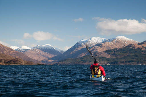
We paddled down the east coast of  Eilean nan Caorach (Sheep Island) and arrived at a beach backed by a cottage, a store house, an...

 ...old pier and three lime kilns. Limestone from the hillside behind the kilns has been quarried away.  The industry lasted for over a hundred years from about 1800.

 The islands in this part of the Firth of Lorn are rich in Dalriadan limestone and this was roasted in the kilns to produce quicklime which was stored...

...in the roofed building on the left of this photo, before being taken away in boats.

The whole operation was run by two families who lived in these cottages.

The  building with the blue doors (behind the quicklime store) was a smithy.

The oldest kiln is now in a pretty unstable state.

A ramp leads up to the top and limestone rubble was dropped into the kiln from...

...above onto a grate below which the coals were lit and then roasted for several days.

The coal was stored in this open walled enclosure behind the quicklime store.

The jetty was used to bring in coal for the kilns and take the quicklime out for agricultural and building purposes. The reef in the middle of this photo is actually a ballast bank where boats dumped ballast before taking on quicklime. At one time there were 24 locally owned smacks which carried coal, limestone and slate. The last was the "Mary and Effie" which was owned by Captain Alan MacFadyen who traded these waters in her until the late 1940's.

The two newer kilns are lined by brick rather than rough stone.

This rowan tree presumably had a sheltered start to life.

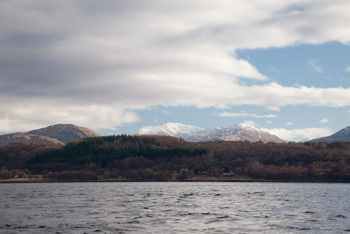
This is the view from the top of the kilns to the north towards Shuna and the Appin hills.

This is the view to the south  The island just beyond the ballast bank is called Inn Island. Many people think that there was once an inn there but it is called this because it was leased together with the Port Appin Inn which can be seen at the foot of the wooded slope on the mainland. InnIsland was originally shown as Island Imachar on the Appin Estate map. The Garvellachs can just be seen on the horizon to the right of centre.

We returned to the base of the Kilns. The largest  is still in pretty good condition and Ian and I crouched down to make our way inside to...

...the main brick lined kiln chamber.

The coal store now shelters an old Mirror dinghy, a kayak and a deflated inflatable all of which have seen better days.

Sunday, February 22, 2015

Is it worth paddle sailing up wind and up tide across the Lynn of Lorn?

It was now time to leave the north of Shuna. The flood tide had already reached the boats.

We managed to get the sails up for a short paddle across the north end of the island but...

...as soon as we turned south down the Sound of Shuna we faced a head wind and the north going tide.

The mooring for the Shuna farm work boats is on the east of Shuna.

As we progressed down the Sound of Shuna there were some bursts of sunlight and...

...to the south the Sgeir Buidhe lighthouse and Eilean Dubh stood out against the glowing sky above the Lynn of Lorn.

From the south end of Shuna it is 1.75km across the north end of the Lynn of Lorn to Eilean nan Caorach (sheep island) which lies off the NE tip of Lismore. The offshore wind was gusting quite badly so Mike and Ian decided to paddle and I stuck my sail up. Although I started on a beam reach, our route took us across a tide that was running at 2 knots. Even maintaining a high ferry angle I ended up paddle sailing close hauled.

This is on Eilean nan Caorach looking back at Shuna.  First of all, note how far down tide (to the left) Ian and Mike have been carried, we set off from the south end of Shuna which is out of picture to the right. Secondly, many people say it is not worth paddle sailing close hauled as the kayak will not plane to windward. However, I beg to differ. I paddle sailed the crossing and arrived 4 minutes and 35 seconds before Ian and Mike arrived by paddling alone.


As you can see, they were in the tide a lot longer and got carried well down tide.

This seal was so busy looking at me he did not notice Ian's approach. It disappeared with a huge splash as...

...Ian passed and finally arrived on Sheep Island. I rest my case m'lud!

Saturday, March 27, 2010

Sea kayaking Loch Creran, Firth of Lorn


A 33km paddle from Port Appin to the head of Loch Creran and back, Feruary 2010.

Tidal streams at NE end of Lynn of Lorn run at 2 knots springs
NE going +0600 HW Oban
SW going -0015 HW Oban

Tidal streams at Loch Creran entrance run at 3-4 knots springs
Ingoing +0600 HW Oban
Outgoing -0030 HW Oban

Tidal streams at Creagan narrows run at 5 knots springs
Ingoing -0520 HW oban
Outgoing +0025 HW Oban overfalls extend for 0.8km into the outer loch.


Paddling NE towards Bein Sgulaird.


Sunset over the distant mountains of Mull.

Little and large on the road north to Appin

The hidden entrance to Loch Creran

Loud, discordant, half naked and very hairy Celts in Loch Creran!

A shilling a whole horse, in Loch Creran

On edge in Loch Creran, a satisfying gurgle from the stern.

Bold kayakers out run speeding glacier!

No food at the inn!

End of day in Loch Creran

After sunset in the Lynn of Lorn.


Photo album map.

After sunset in the Lynn of Lorn.


The ebb tide carried us out of Loch Creran and into the Lynn of Lorn.


It was half an hour past sunset and the light was fading fast as the bubbling tide carried us by the pole marking Dearg Sgeir.


The air was so clear that we could see all the way down the Firth of Lorn past the distant mountains of Mull...


...but we now turned our bows to the NE. Only a few scattered lights on Lismore and the snowy summits of Morvern resisted the relentless approach of the darkness of the night.


The snowy summit of Ben Cruachan glowed softly in the night, beyond the wooded slopes of Clach Tholl, a former sea stack.


Ahead, the lights at the pier head at Port Appin told us that we would soon have finished another superb paddle.

Thursday, March 11, 2010

The hidden entrance to Loch Creran


Travelling south from Port Appin we paddled below this interesting former sea stack. It has a wooded summit, steep wave cut cliffs and it sits high and dry on a raised beach which connects it to the Appin mainland.


It even has a natural arch cut by a former higher sea level.


From the sea, the wooded isle of Eriska almost completely blocks the tortuous entrance to lovely Loch Creran which lies hidden below the distant mountains.


Suddenly this barge appeared from the midst of the woods! She is the MV Rose of Lorne and was built in 1965. She ferries supplies to the Glensanda quarry which has no road access but is one of the biggest quarries in Europe. In 2008 she gained a second storey to her wheelhouse. She was contracted to transport 8 giant dump trucks from Oban to Glensanda. The captain needed to be higher to see where he was going! Normally the Rose of Lorne operates between Barcaldine in Loch Creran and Glensanda.


We now entered the winding entrance to the loch. It is fringed by great banks of gravel, which were left by the melting glacier that once carved its way to the sea here.


Once we passed the gravel and woodlands of Eriska, we began to see our way round to the hidden loch.